Many areas along the southern Atlantic coast are likely to experience a thorough soaking, but some locales can be hit particularly hard with flooding downpours and locally strong wind gusts.
AccuWeather Global Weather Center – August 25, 2021
As a storm rolls westward from the Atlantic, some people in the southeastern United States can expect a break from extreme heat by way of drenching thunderstorms over the next few days, but some of the same locations and others can be slammed by flash flooding and gusty winds from storms that become stronger, AccuWeather meteorologists caution.
At first glance at satellite photos, a mass of clouds located just north of Hispaniola and just east of the Bahamas might appear to be a large tropical storm. There is a storm located in that region of the Atlantic, but it is situated in the middle part of the atmosphere. Tropical systems tend to dwell in the lower part of the air above the ocean surface.
If given enough time and certain atmospheric conditions, middle- and upper-level storms can spin down to the lower part of the atmosphere and take on tropical characteristics.
"We track every ripple, tropical wave and middle- and upper-level storm during the tropical season, but this system is probably moving too fast to evolve into a tropical depression or storm," AccuWeather Chief On-Air Meteorologist Bernie Rayno said.
Brewing tropical system in Caribbean may take aim at US Gulf Coast

"All residents and concerns in the Yucatan Peninsula and across northeast Mexico and southern and even East Texas should closely monitor this system," AccuWeather Hurricane Expert Dan Kottlowski said.
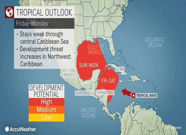
AccuWeather Global Weather Center – August 25, 2021 – AccuWeather meteorologists project that a tropical wave sweeping through the Caribbean Sea will have a high likelihood of becoming a named system as it nears Central and North America later this week and into early next week. Areas of Mexico that were ravaged by Hurricane Grace may again be in the path of this new tropical threat, and forecasters cannot rule out the potential for a future direct impact in the United States.
The feature under scrutiny, designated as Invest 99L by the National Hurricane Center, remained largely disorganized during the early part of this week as it produced showers and breezy conditions across parts of the Caribbean and northern portions of South America.
Tropical development is not expected to occur through at least Thursday due to increasing wind shear in the path of the disturbance.
"Even if it does not strengthen in the short-term, the tropical wave can enhance showers and thunderstorms through Thursday across Jamaica and the Cayman Islands, two areas that were also pummeled by Grace's heavy rain last week," AccuWeather Senior Meteorologist Adam Douty said.
About AccuWeather, Inc. and AccuWeather.com
AccuWeather, recognized and documented as the most accurate source of weather forecasts and warnings in the world, has saved tens of thousands of lives, prevented hundreds of thousands of injuries and tens of billions of dollars in property damage. With global headquarters in State College, PA and other offices around the world.
