MIAMI (AP) — Many people evacuated from vulnerable locations in the northwestern Bahamas as Tropical Storm Nicole approached Wednesday and residents of Florida braced for the storm, which could strengthen to a hurricane.
Not much has changed with Nicole. It is still forecast to become a Cat.1 Hurricane as it moves across the NW Bahamas today and expected to make landfall along the East coast of Florida tonight. Expect heavy rain, flooding, gusty winds in South Florida. Tri-Rail and Brightline are going to suspend services ahead of Tropical Storm Nicole.
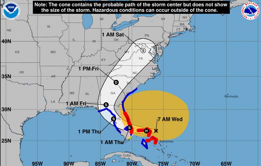
Nicole was expected to be the first storm to make landfall in the Bahamas since Hurricane Dorian, a devastating Category 5 storm that hit the archipelago in 2019, before hitting storm-weary Florida on Wednesday night and moving into Georgia on Thursday.
In the Bahamas, officials said early Wednesday that only a few people were in the more than two dozen shelters that opened.
“We are asking people to please take it (seriously),” said Andrea Newbold with the Disaster Management Unit for Social Services. “Don’t wait until the last minute.”
Residents in at least three Florida counties — Flagler, Palm Beach and Volusia — were ordered to evacuate from barrier islands, low-lying areas and mobile homes. The evacuation orders went into effect Wednesday morning. Officials at Orlando International Airport, the seventh busiest in the U.S., said commercial operations would stop Wednesday afternoon until it was safe to resume flights. And Palm Beach International Airport planned to close.
Bahamas Prime Minister Philip Brave Davis said he has mobilized all government resources as the storm nears.
“There have always been storms For those in Grand Bahama and Abaco, I know it is especially difficult for you to face another storm,” Davis said, referring to the hardest hit islands by Dorian.
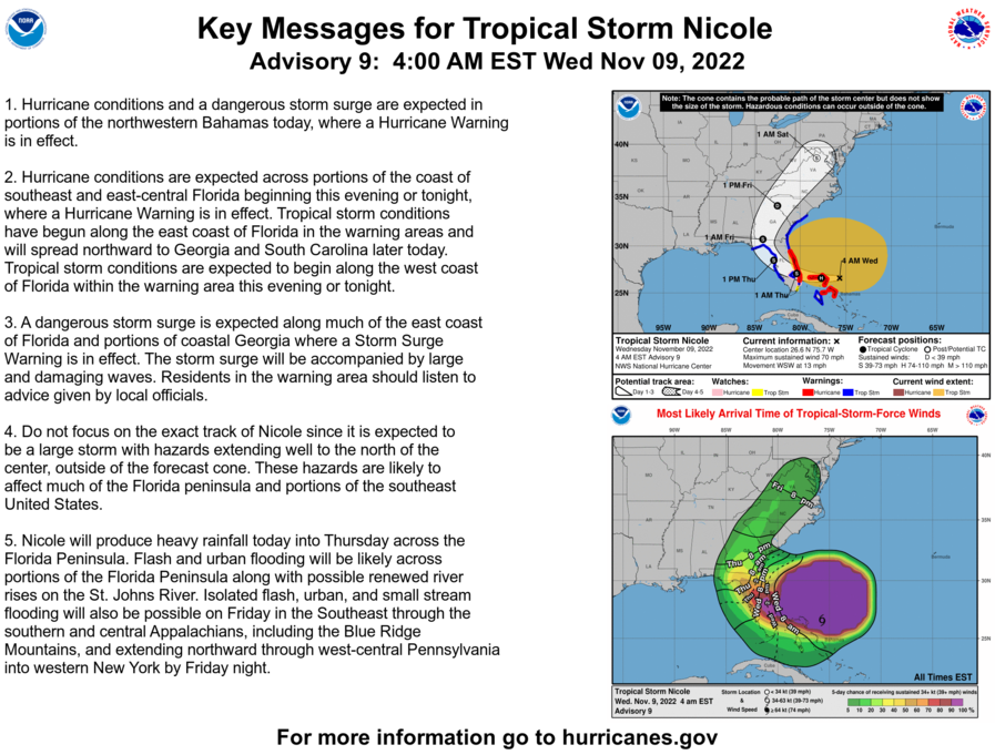
At 7 a.m., the storm was 60 miles east northeast of Great Abaco Island and about 240 miles east of West Palm Beach, Florida. With maximum sustained winds of 70 mph, the storm was moving at 13 mph).
Flash and urban flooding will be likely, along with possible renewed river rises on the St. Johns River, across the Florida Peninsula today into Thursday. Heavy rainfall from this system will spread northward across portions of the Southeast, Mid-Atlantic, and New York Thursday into Friday night, where flooding impacts will be possible.
New warnings and watches were issued for many parts of Florida, including the southwestern Gulf coastline which was devastated by Hurricane Ian, which struck as a Category 4 storm on Sept. 28. The storm destroyed homes and damaged crops, including orange groves, across the state.
Ian lashed much of the central region of Florida with heavy rainfall, causing flooding that many residents are still dealing with as Nicole approaches. Forecasters at the Miami-based National Hurricane Center said the storm could reach hurricane strength before making landfall in Florida.
In preparation, many school districts in Florida canceled classes on Wednesday and Thursday.
Early Wednesday, President Joe Biden declared an emergency in Florida and ordered federal assistance to supplement state, tribal and local response efforts to the approaching storm. The Federal Emergency Management Agency is still responding to those in need from Hurricane Ian.