National Weather Service - Sacramento: Forecast Discussion:
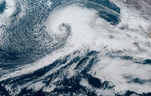
A much stronger storm will spread into the region bringing strong, damaging winds with heavy rain and mountain snow Wednesday through Thursday. This is hybrid storm, with a deep Pacific low off the coast tapping into a very moist Atmospheric River(AR). The combination of strong dynamic lift and abundant moisture will bring moderate to heavy rain and heavy mountain snow, especially Wedensday evening into early Thursday. Elevated flood and recent burn scar concerns are expected, as well as major mountain travel impacts in periods of heavy snow are expected. A strong surface pressure gradient coupled with a strong low level wind jet (65 kt at 925mb) will bring increasing southerly winds through the day Wednesday, peaking Wednesday night. Sustained winds 25 to 35 mph with gusts up to 50 to 60 mph are expected in the Valley and foothills, so the High Wind Watch has been upgraded to a Warning from 10 AM PST Wednesday to 4 pm PST Thursday.
These strong winds coupled with saturated ground will likely bring down trees and cause the potential for widespread power outages. This will also cause difficult travel for high profile vehicles such as trucks and RVs. The wind is expected to diminish Thursday evening. Precipitation will spread into the area with a warm front early Wednesday.

The city of San Jose jumped in early, proclaiming a State of Emergency on Tuesday ahead of the weather event.
In addition, rain will spread over the coast and valleys of Washington State and Oregon, with snow developing across the mountains and higher elevations of the Northwest, California and Great Basin.
There is a moderate risk of excessive rainfall over parts of the California Coast on Wednesday and a slight risk of excessive rainfall over parts of California on Thursday.
Snow levels will initially be low early Wednesday, around 4,000 feet, then rapidly with warmer air advecting in to around 7,000 feet Wednesday night. Snow levels will drop to around 5,550 feet early Thursday behind a cold front. The majority of the snow is expected above 5,000 feet, but snow levels associated with AR`s can be tricky, resulting in either higher or lower snow levels at times. If driving along roadways between 4000-6000 feet, be prepared for both heavy rain and/or heavy snowfall. Mountain travel impacts are likely, with 1 to 3 feet of mountain snow, locally hight over peaks. Snow may fall at rates up to 3 inches an hour, bringing very slippry conditions and whiteout conditions, when combined with winds gusting to 60 to 70 mph. The winds could also bring down trees, potentially blocking roads and causing power outages.
The Winter Storm Warning continues for elevations above 5,000 feet from 7 am PST Wednesday through 4 AM PST Friday. The wet moisture tap from the AR will bring moderate to heavy rain for elevations below 5,000 feet. Uplsope flow will be less of a factor than the previos system, with rainfall amounts 1.50 to 3.00 inches in the Valley, with 3 to 7 inches in the foothills and mountains. Rainfall will bring river rises, as well as renewed flooding threats, mainly to small streams and creeks and to low lying areas. This is due to streams already being elevated by the previous storm, as well as saturated ground. A Flood Watch continues for the Valley, Delta and foothills from Wednesday morning through Friday morning.
